Plateau Lava
A lava plateau is a broad, elevated tableland or flat-topped highland, usually many hundreds or thousands of square kilometers in extent, underlain by a thick succession of lava flows, most of which are tholeiitic basalts and the product of fissure eruptions.
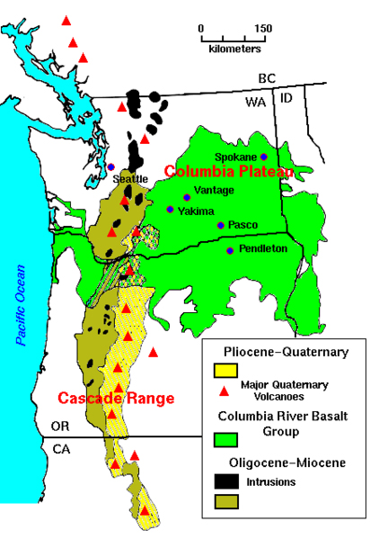
One example is the Columbia Plateau in Washington, Oregon, and Idaho; it is 160,000 km² (63,000 square miles) in area and 1.8 km (~6,000 ft) thick. Another example is the Deccan Plateau in India.
Columbia River Plateau is a geologic and geographic region that lies across parts of the U.S. states of Washington, Oregon, and Idaho. It is a wide flood basalt plateau between the Cascade and Rocky Mountains, cut through by the Columbia River. In common usage, the term 'Columbia Basin' refers to more or less the same area as the Columbia Plateau.
During late Miocene and early Pliocene times, one of the largest flood basalts ever to appear on the earth's surface engulfed about 63,000 square miles (160,000 km²) of the Pacific Northwest, forming a large igneous province. Over a period of perhaps 10 to 15 million years lava flow after lava flow poured out, eventually accumulating to a thickness of more than 6,000 feet (1.8 km). As the molten rock came to the surface, the earth's crust gradually sank into the space left by the rising lava.
The subsidence of the crust produced a large, slightly depressed lava plain now known as the Columbia Basin or Plateau. The ancient Columbia River was forced into its present course by the northwesterly advancing lava. The lava, as it flowed over the area, first filled the stream valleys, forming dams that in turn caused impoundments or lakes. Entities that have been found in these lake beds are fossil leaf impressions, petrified wood, fossil insects, and bones of vertebrate animals.
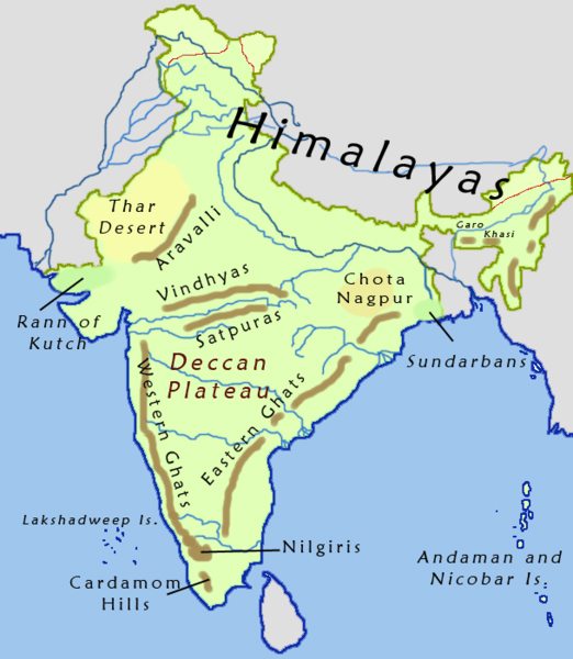
The Deccan Traps are a large igneous province located on the Deccan Plateau of west-central India (between 17-24N, 73-74E) and one of the largest volcanic features on Earth. They consist of multiple layers of solidified flood basalt that together are more than 2,000 m thick and cover an area of 500,000 km². The term 'traps' is derived from the Swedish word for stairs (trappa, or sometimes trapp), referring to the step-like hills forming the landscape of the region.
The Deccan Traps formed between 60 and 68 million years ago, at the end of the Cretaceous period. The bulk of the volcanic eruption occurred at the Western Ghats (near Bombay) some 66 million years ago. This series of eruptions may have lasted fewer than 30,000 years in total. The gases released in the process may have played a role in the Cretaceous–Tertiary extinction event, which included the extinction of the dinosaurs.
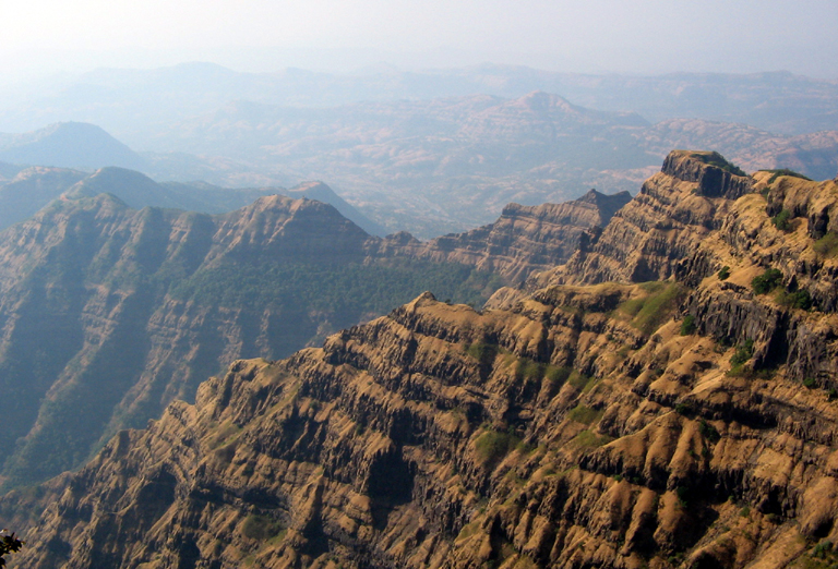
Before the Deccan Traps region was reduced to its current size by erosion and continental drift, it is estimated that the original area covered by the lava flows was as large as 1.5 million km², approximately half the size of modern India. The present volume of directly observable lava flows is estimated to be around 512,000 km³.
The release of volcanic gases during the formation of the traps "contributed to an apparently massive global warming. Some data point to an average rise in temperature of 8 °C (14 °F) in the last half million years before the impact at Chicxulub."
Planetary Impact
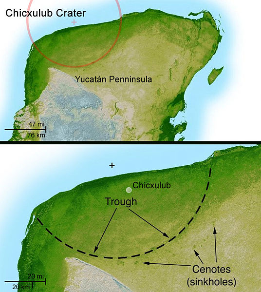
The Chicxulub Crater (IPA: [tʃikʃuˈlub]) is an ancient impact crater buried underneath the Yucatán Peninsula in Mexico. Its center is located near the town of Chicxulub, after which the crater is named—as well as the rough translation of the Mayan name, "the tail of the devil." The crater is more than 180 kilometers (110 mi) in diameter, making the feature one of the largest confirmed impact structures in the world; the impacting bolide that formed the crater was at least 10 km (6 mi) in diameter.
The crater was discovered by Glen Penfield, a geophysicist who had been working in the Yucatán while looking for oil during the late 1970s. Evidence for the impact origin of the crater includes shocked quartz, a gravity anomaly, and tektites in surrounding areas. The age of the rocks and isotope analysis show that this impact structure dates from the end of the Cretaceous Period, roughly 65 million years ago. The impact associated with the crater is implicated in causing the extinction of the dinosaurs as suggested by the K–T boundary, although some critics argue that the impact was not the sole reason and others debate whether there was a single impact or whether the Chicxulub impactor was one of several that may have struck the Earth at around the same time. Recent evidence suggests that the impactor was a piece of a much larger asteroid that broke up in a collision in distant space more than 160 million years ago.
It is postulated that the Deccan Traps eruption was associated with a deep mantle plume. The area of long-term eruption (the hotspot), known as the Réunion hotspot, is suspected of both causing the Deccan Traps eruption and opening the rift that once separated the Seychelles plateau from India. Seafloor spreading at the boundary between the Indian and African Plates subsequently pushed India north over the plume, which now lies under Réunion island in the Indian Ocean, southwest of India. The mantle plume model has, however, been challenged.
A suspected large impact crater has been recently reported in the sea floor off the west coast of India. Called the Shiva crater, it has also been dated at sixty-five million years, right at the K–T boundary. The researchers suggest that the impact may have been the triggering event for the Deccan Traps as well as contributing to the acceleration of the Indian plate in the early Tertiary. However, opinion in the geologic community is not unanimous that this feature is actually an impact crater. Also, the reported age is in the middle of the ages given for the Deccan rocks.
Due to the volcanic gases causing a drastic climate change the formation of the traps is seen as a major stressor on all life at the time. Dr. Norman Macleod, of the Natural History Museum in London, points out “We're talking about catastrophic effects in terms of changes in habitat, changes in rain fall patterns, changes in climate, all of these you can think of all of the things that are going on in the modern world magnified many many times, many many orders of magnitude indeed.” While the fossil record of dinosaurs at this time is hard to interpret, those of other types of life are more conclusive, as Macleod states “Six million years prior to the K–T boundary there were about twenty species of ammonites in the world's oceans. Three million years before the K–T boundary there were only fifteen or so and one million years prior to the K–T boundary we have less than half of what we started out with, we have less than ten species so the extinction event has already been going on for millions of years. The amazing thing is that we see the same pattern in the fish record, we see the same pattern in the terrestrial reptile record, we even see the same pattern in the mammal record. All of these groups were undergoing an extinction event for millions of years and it would be absolutely amazing to me if dinosaurs weren't undergoing the same sort of extinction and indeed I think they were undergoing the same sort of long term extinction.” Many scientists theorize that due to the global warming caused by the volcanic formation of the traps the dinosaurs were already doomed, but the impact of the meteoroid that formed the Chicxulub Crater (which made a sunlight blocking dust cloud that killed much of the plants) pushed them over the edge into extinction.
SuperVolcano
The latest eruption of Mt. Etna in Sicily, which has destroyed a few buildings, shut down the airport and crept into a ski area, produces dramatic nighttime video of hot rolling lava and explosive fireworks. But compared to the known history of volcanoes and even its own past, Etna's 2001 pyrotechnic show is so far geologically pathetic.
Likewise, the eruption of Mt. St. Helens in 1980 was a volcanic sneeze compared to what scientists say America will experience one day. And a mysterious four-inch-high bulge in the ground of central Oregon is, so far, little more than a conversation piece. Sooner or later, geologists warn, a "super volcano" will strike.
The eruption of pent-up energy will cover half the United States in ash, in some places up to 3 feet (1 meter) deep. Earth will be plunged into a perpetual winter that would last years. Some plant and animal species will disappear forever.
Even humans could be pushed to the edge of extinction. Anthropologists suggest it won't be the first time.
But well before such a calamity, warning flags will likely show up on the computers of geologists around the world who monitor an increasingly useful stream of satellite data.
A supervolcano or super volcanic eruption is a volcanic eruption which is orders of magnitude greater than any volcano in historic times, sufficient to cause long-lasting change to weather, threaten the extinction of species, and cover huge areas with lava and ash.
The term was originally used in the BBC popular science program, Horizon, in 2000 to refer to these types of eruption. That programme introduced the subject to the public.
Volcanologists and geologists do not refer to "super volcanoes" or "megacalderas" in their scientific work, but sometimes do in public presentations. However, they do describe eruptions that rate VEI 7 or 8 as "super eruptions".
* Until 2003, supervolcano was not a technical term used in volcanology. The term megacaldera is sometimes used for caldera supervolcanoes, such as the Blake River Megacaldera Complex in the Abitibi greenstone belt of Ontario and Quebec, Canada.
* Though there is no well-defined minimum explosive size for a "supervolcano", there are at least two types of volcanic eruption that have been identified as supervolcanoes: massive eruptions.
A large igneous province (LIP) e.g. Iceland, the Siberian Traps, Deccan Traps, Ontong Java Plateau are extensive regions of basalts on a continental scale, resulting from flood basalt eruptions. When created, these regions often occupy several thousand km2 and have volumes on the order of millions km3. In most cases, the lavas are normally laid down over several million years. They do release massive amounts of gases. The Réunion hotspot produced the Deccan Traps about 65 Mya. Research continues into the effect of the outpourings and whether they impacted upon the extinction of the dinosaurs at the end of the Cretaceous.
Such outpourings are not explosive though fire fountains may occur. Many volcanologists consider that Iceland may be a LIP that is currently being formed. The last major outpouring occurred in 1783-1784 from the Laki fissure which is ~40 km long. An estimated 14 km3of basaltic lava was poured out during the eruption.
The Ontong Java Plateau has an area of about 2 million km2 .
Yellowstone Caldera
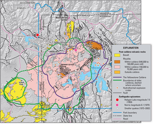
The Yellowstone Caldera is the volcanic caldera in Yellowstone National Park in the United States. It is located in the northwest corner of Wyoming, measuring about 55 kilometers (34 mi) by 72 kilometers (45 mi). The caldera was discovered based on geological field work conducted by Bob Christiansen of the United States Geological Survey in the 1960s and 1970s. After a BBC television science program coined the term supervolcano in 2000, it has often been referred to as the "Yellowstone supervolcano."
Yellowstone, like the Hawaiian Islands, is believed to lie on top of one of the planet's few dozen hotspots where light, hot, molten mantle rock rises towards the surface. The Yellowstone hotspot has a long history. Over the past 17 million years or so, successive eruptions have flooded lava over wide stretches of Washington, Oregon, California, Nevada, and Idaho, forming a string of comparatively flat calderas linked like beads, as the North American plate moves across the stationary hotspot. The oldest identified caldera remnant is straddling the border near McDermitt, Nevada-Oregon. The caldera's apparent motion to the east-northeast forms the Snake River Plain. However, what is actually happening is the result of the North American plate moving west-southwest over the stationary hotspot deep underneath.
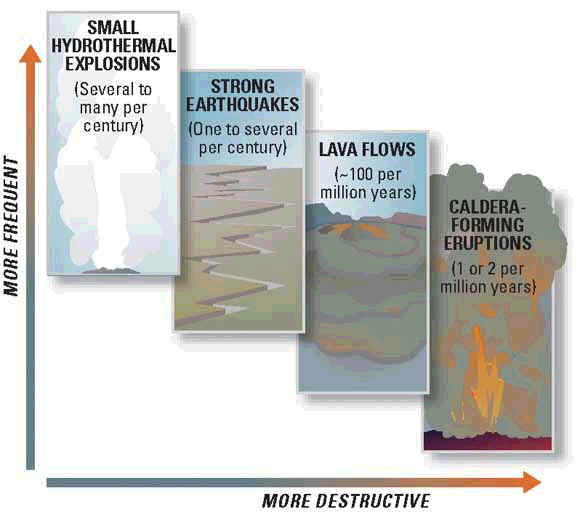
Currently, volcanic activity is exhibited only via numerous geothermal vents scattered throughout the region, including the famous Old Faithful Geyser, but within the past two million years, it has undergone three extremely large explosive eruptions, up to 2,500 times the size of the 1980 Mount St. Helens eruption. The three eruptions happened 2.1 million years ago, 1.3 million years ago, and the most recent such eruption produced the Lava Creek Tuff 640,000 years ago and spread a layer of volcanic ash over most of the North American continent. Smaller steam explosions occur every 20,000 years or so; an explosion 13,800 years ago left a 5 kilometer diameter crater at Mary Bay on the edge of Yellowstone Lake (located in the center of the caldera). Additionally, non-explosive eruptions of lava flows have occurred in and near the caldera since the last major eruption; the most recent of these was about 70,000 years ago. Craters of the Moon National Monument in Idaho is the result of volcanic activity between 11,000 and 2,000 years ago.
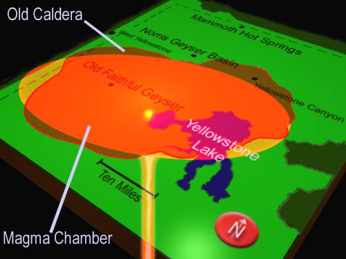
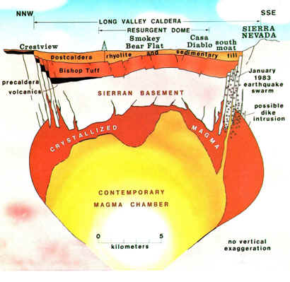
The volcanic eruptions, as well as the continuing geothermal activity, are a result of a large chamber of magma located below the caldera's surface. The magma in this chamber contains gases that are kept dissolved only by the immense pressure that the magma is under. If the pressure is released to a sufficient degree by some geological shift, then some of the gases bubble out and cause the magma to expand. This can cause a runaway reaction. If the expansion results in further relief of pressure, for example, by blowing crust material off the top of the chamber, the result is a very large gas explosion.
A full-scale eruption of the Yellowstone caldera could result in millions of deaths locally. The last full-scale eruption, the so-called Lava Creek eruption, ejected approximately 240 cubic miles of rock and dust into the sky and is believed to have almost driven the young human race to extinction, over 600,000 years ago.
Geologists are closely monitoring the rise and fall of the Yellowstone Plateau, which averages +/- 0.6 inches (about 1.5 cm) yearly, as an indication of changes in magma chamber pressure. Explosions of this magnitude "happen about every 600,000 years at Yellowstone," says Chuck Wicks of the U.S. Geological Survey, who has studied the possibilities in separate work. "And it's been about 620,000 years since the last super explosive eruption there." The U.S. Geological Survey, University of Utah and National Park Service scientists with the Yellowstone Volcano Observatory "see no evidence that another such cataclysmic eruption will occur at Yellowstone in the foreseeable future. Recurrence intervals of these events are neither regular nor predictable
Studies and analysis may indicate that the greater hazard comes from hydrothermal activity which occurs independently of volcanic activity. Over 20 large craters have been produced in the past 14,000 years since the glaciers retreated from Yellowstone, resulting in such features as Mary Bay, Turbid Lake and Indian Pond.
Lisa Morgan, a USGS researcher, explored this threat in a 2003 report, and again in a 2008 report revealed further that an earthquake may have displaced more than 77 million cubic feet (2,200,000 m³) of water in Yellowstone Lake, creating huge waves that essentially unsealed a capped geothermal system leading into the hydrothermal explosion that formed Mary Bay.
Other research shows that earthquakes from great distances do reach and have effects upon the activities at Yellowstone, such as the 1992 7.3 magnitude Landers earthquake in California’s Mojave Desert that triggered a swarm of quakes from more than 800 miles (1,300 km) away and the Denali fault earthquake 2,000 miles (3,200 km) away in Alaska that altered the activity of many geysers and hotsprings for several months afterwards.
The head of the Yellowstone Volcano Observatory, Jake Lowenstern, has proposed major upgrades and extended monitoring since the federal government classified Yellowstone as a “high-threat” system.

No comments:
Post a Comment